Monday, January 12, 2026


Wednesday, August 06, 2025
Monday, December 18, 2023
Monday, June 04, 2018
Sunday, January 10, 2016
Yellowstone about to blow?
SCIENTISTS have warned the world is in "volcano season" and there is up to a 10% chance of an eruption soon killing millions of people and devastating the planet.
PUBLISHED: 04:05, Thu, Jan 7, 2016 | UPDATED: 14:25, Thu, Jan 7, 2016

Instances of volcanic eruptions are their highest for 300 years and scientists fear a major one that could kill millions and devastate the planet is a real possibility.
Experts at the European Science Foundation said volcanoes – especially super-volcanoes like the one at Yellowstone National Park, Wyoming, which has a caldera measuring 34 by 45 miles (55 by 72 km) - pose more threat to Earth and the survival of humans than asteroids, earthquakes, nuclear war and global warming.
There are few real contingency plans in place to deal with the ticking time bomb, which they conclude is likely to go off within the next 80 years.
The world's most dangerous active volcanoes include Yellowstone, Mount Vesuvius in Campagnia, Italy, and Popocatépetl i near Mexico City.
If any of them or other massive volcanic peaks suffered a major eruption the team said millions of people would die and earth’s atmosphere would be poisoned with ash and other toxins "beyond the imagination of anything man’s activity and global warming could do over 1,000 years.
The chance of such as eruption happening at one of the major volcanoes within 80 years is put at five to ten per cent by the experts.

There are already fears that Yellowstone could blow any time within the next 70 years on a scale that would wiped out the western USA and affect the course of global history.
The report - “Extreme Geo-hazards: Reducing the Disaster Risk and Increasing Resilience,” warns global government's preparations for such happenings are virtually non-existent.
It said: "Although in the last few decades earthquakes have been the main cause of fatalities and damage, the main global risk is large volcanic eruptions that are less frequent but far more impactfull than the largest earthquakes.
“Due to their far-reaching effects on climate, food security, transportation, and supply chains, these events have the potential to trigger global disaster and catastrophe.
"The cost of response and the ability to respond to these events is beyond the financial and political capabilities of any individual country.”
The Yellowstone volcanoThu, January 7, 2016
The volcano at Yellowstone National Park in Wyoming and Montana sits atop a huge reserve of magma and last erupted 640,000 years ago


Hence extreme volcanic eruptions pose a higher associated risk than all other natural hazards with similar recurrence periods, including asteroid impacts.
Extreme Geo-hazards: Reducing the Disaster Risk and Increasing Resilience report
The report looked at other major geo-hazards facing the globe, including earthquakes, drought, asteroids floods, tsunamis, hurricanes, avalanches and wildfires.
Large earthquakes and tsunamis have happened more in the last 2,000 years, meaning there was better preparedness.
The report concluded: “Volcanic eruptions can have more severe impacts through atmospheric and climate effects and can lead to drastic problems in food and water security, as emphasized by the widespread famine and diseases that were rampant after the Laki 1783 and Tambora 1815 eruptions.
“Hence extreme volcanic eruptions pose a higher associated risk than all other natural hazards with similar recurrence periods, including asteroid impacts.”
The eruption of Tambora on Sumbawa, Indonesia killed about 100,000 people, but ash clouds meant there was no summer the following year and it was “one of the most important climatic and socially repercussive events of the last millennium,” the report said.
The earlier Icelandic event killed close to 10,000 instantly, but the long-term, effects wiped out 25% of the population and were felt across the planet.
A famine in Egypt reduced the population by one sixth, 25,000 died in the UK from breathing problems and there was worldwide extreme weather.
Similar scale events today would be much more catastrophic, the team warned, due to
much bigger populations, global travel and food chains and reliance on technology.
Worryingly, scientists say research over the last 300 years of volcanic activity shows we are currently in a "volcano season" meaning increased activity.
Volcanoes are also more likely from November to April in the northern hemisphere when ice, rain and snowfall can compress the bedrock.
Tuesday, March 13, 2012
Friday, October 14, 2011
Canary Island Eruption Emerges Under Water

October 14, 2011
Two separate ocean floor fissures, and stains on the water, have been observed near El Hierro's coast.
Months of volcanic tremors on Spain’s Canary Island of El Hierro appear to be associated with two undersea eruptions that began about two miles off the island’s southeastern coast.
The country’s National Geographic Institute told reporters that dead fish were seen floating on the ocean surface above where the eruption emerged.
The institute’s scientists said they were not yet able to determine if the eruptions, at a depth of about 1,500 feet, were spewing lava or gas.
It now appears unlikely that the more than 9,000 tremors that have jolted El Hierro since July 17 will lead to another eruption on the island.
People who had left their homes over volcanic fears returned home, and officials announced they were going to reopen the islands’ most important road tunnel, which had been closed as a precautionary measure.
The island's only eruption in recorded history was in 1793, when it rumbled for about one month with flows of lava.
Tuesday, October 11, 2011
Canaries volcano prompts evacuation

Valverde - An underwater volcanic eruption has prompted the authorities to evacuate about 500 people from a village on Spain's El Hierro island in the Canaries, officials said on Tuesday.
The eruption was detected on Monday 5km from the island at a depth of between 500 and 1 200m beneath the sea.
Experts had said the eruption would not be felt on the island.
But seismic activity now pointed to the risk of another eruption closer to the coast, said the director general of the Canaries' emergency commission, Juan Manuel Santana.
As a result, the regional government will relocate the roughly 500 people living in La Restinga, which is the closest residential area to the eruption, he told a news conference.
"An eruption in shallower waters would produce a greater risk because of the greater interaction of the water with the magma," he warned.
"We must continue to follow how the phenomenon develops, what we are putting in place is simply a preventative measure."
Village residents will probably be transferred to facilities at a football field further inland, the regional government of the Canaries said in a statement.
Spanish Prime Minister Jose Luis Rodriguez Zapatero met with several ministers, including Defence Minister Carmen Chacon, and volcano experts later on Tuesday to analyse the situation, his office said.
The regional government of the archipelago on Monday issued a "yellow" volcanic eruption alert - the second level on a scale of four - after the island was hit by a 4.3-magnitude quake.
El Hierro, which means iron in Spanish, is the smallest of Spain's Canary Islands, located in the Atlantic off the coast of Morocco. It is home to some 11 000 people.
The last volcanic eruption on the Canary Islands was on nearby La Palma in 1971.
Source
Wednesday, October 05, 2011
Busy September for Costa Rican volcanoes
- By Erik Klemetti
- October 4, 2011 |
- 4:56 am

Hard to believe we’ve already entered October, eh?
Some news on volcanic rumblings from Costa Rica:

The summit region of Costa Rica's Rincón de la Vieja in an undated image.
We tend to talk about three volcanoes in Costa Rica: the ever-active Arenal, the renewed Turrialba and Poás. Now we can add another volcano to the watch list, that being Rincón de la Vieja (see above). Like the other Costa Rican volcanoes, it is a composite volcano with overlapping craters at its summit. It is a hulk of a volcano with a total volume of over 130 km3 – and I love that the Global Volcanism Programsummary refers to it as the “Colossus of Guanacaste”. Most of the volcanoes known eruptions have been in the VEI 1-3 range until we get back to ~1820 BC, when a VEI 4 eruption produced pyroclastic flows. The volcano has seen somewhat-persistent fumarolic activity since its last eruptive period in 1995-98 with tremors reported in 2008. However, last month Rincón de la Vieja produced phreatic eruptionsthrough the small lake at the summit crater (see below). During the middle of September, small explosions, ash falls and fish kills were reported at the summit area of Rincón de la Vieja and a visit to the area by OVSICORI scientists revealed 10-15 cm layers of ash – mostly accidental sediment spit back out of the crater lake (pdf in spanish) – in the surrounding area. This new activity has prompted the government to limit access to Rincón de la Vieja and set up a new seismometer north of the volcano.

The crater lake at the summit of Rincón de la Vieja seen in mid-September, 2011. The debris on the edges of the lake were deposited in phreatic (steam-driven) explosions). Image from OVSICORI.
Meanwhile, at Poás, thecrater lake at the summit of that volcano (spanish) has dried up due to the elevated temperatures at the summit fumaroles. When the wind is low, steam plumes from the vigorous fumaroles can be seen in the nearby valleys. There was also an incandescent dome spotted in the last month at the volcano.Turrialba has also seen increase in activity as well. It has been producing light ash falls near the volcano, but theconstant release of volcanic gases such as sulfur dioxide have produced corrosion up to a few kilometers from the vent. Surprisingly, the poster child for Costa Rican volcanoes, Arenal, has been very quite of late, but that doesn’t mean that you can’t find amazing pictures of the volcano, showing the denuded flanks on the volcano mixed with the lush vegetation of the area.
Want to check out some of the activity? There are multiple webcams run by OVSICORI for Arenal, however, it looks like the webcam for Turrialba is out of commission right now. If you know of any other Costa Rica volcano webcams, let us know in the comments below!
Follow @eruptionsblog on Twitter.
Source
Wednesday, August 10, 2011
Surprise! Underwater volcano has erupted

Bill Chadwick, Oregon State University, © Woods Hole Oceanographic Institution
The chain is all that is visible of an ocean-bottom hydrophone, an instrument that detects earthquakes, buried in about 6 feet of new lava produced by a recent eruption at the Axial Seamount.
By Andrea Mustain
OurAmazingPlanet
updated 8/9/2011 5:36:28 PM ET
An undersea volcano has erupted off the coast of Oregon, spewing forth a layer of lava more than 12 feet thick in some places, and opening up deep vents that belch forth a cloudy stew of hot water and microbes from deep inside the Earth.
Scientists uncovered evidence of the early April eruption on a routine expedition in late July to the Axial Seamount, an underwater volcano that stands 250 miles off the coast of Oregon.
The discovery came as a surprise, as researchers attempted to recover instruments they'd left behind to monitor the peak a year earlier. When the researchers hefted a seafaring robotic vehicle overboard to fetch the instruments, the feed from the onboard camera sent back images of an alien seafloor landscape.
"At first we were really confused, and thought we were in the wrong place," said Bill Chadwick, a geologist with Oregon State University. "Finally we figured out we were in the right place but the whole seafloor had changed, and that's why we couldn't recognize anything. All of a sudden it hit us that, wow, there had been an eruption. So it was very exciting."
In addition to producing hardened lakes of blobby lava, in places more than a mile across, the eruption changed the architecture of the region's seafloor hot springs.
"There are more vents, they're higher temperature, and there are microbes living in them that are usually deep in the crust that come up to the surface in these events," Chadwick told OurAmazingPlanet.
Eruption predicted
The Axial Volcano rises 3,000 feet above the seafloor, the most active of a string of volcanoes along the Juan de Fuca Ridge, a plate boundary where the seafloor is slowly pulling apart.
Chadwick and colleagues have been keeping tabs on the peak since it last erupted in 1998. Thanks to a monitoring system they developed to measure the mountain's minute movements, the team predicted the volcano was due for another eruption sometime between 2011 and 2014.
"So for me, it's a very exciting thing that this worked!" Chadwick said.
The instruments kept track of the movement of the seafloor, which very gradually inflates and deflates like a giant, magma-filled balloon, Chadwick said, collapsing suddenly after an eruption, and rising, in this case, by about 6 inches a year in the lead-up to an eruption.
First long-term picture
Scientists have long known about the existence of subsea volcanoes, but information on their behavior is relatively sparse. Eruptions were first observed in the 1990s, and, although technology has improved, getting to the underwater peaks to study them is difficult.
Data from the Axial Seamount's recent eruption will provide the first long-term picture of a subsea volcano from one eruption to the next.
Chadwick said scientists are still trying to figure out how seafloor volcanoes differ from their terrestrial counterparts.
It could be it's easier to predict ocean eruptions, Chadwick said. It's possible that because the crust is thinner there, and magma is in ready supply, the mountains' slow inflations provide a good analogue for knowing when eruptions will occur. However, he cautioned that a single successful prediction wasn’t enough to forecast what the future holds.
"At Axial, we've only seen this once, so we don't know for sure it's going to be reliable," Chadwick said. "So we'll certainly keep making these measurements, and hopefully be around to see what happens next."
Reach Andrea Mustain at amustain@techmedianetwork.com . Follow her on Twitter @AndreaMustain .

Bill Chadwick, Oregon State University, © Woods Hole Oceanographic Institution
Before the eruption: A spider crab sits atop a hydrophone, an instrument that detects earthquakes, at the Axial Seamount.
Source
.
Saturday, December 04, 2010
Volcano known as the 'Throat of Fire' erupts in Ecuador
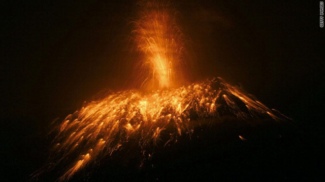
Residents evacuated the area after the country's National Agency of Risk Control issued a "red alert." The warning was later downgraded to orange, as the volcano became less active.
Activity at Tungurahua -- which means "throat of fire" in the native Quechua language -- peaked Saturday between 8 a.m. and 2 p.m., according to the Geological Institute in Quito.
At one point, the ash cloud reached nearly 3 km (1.9 miles) above the volcano's crater, according to the institute, and lava flowed about 2 km from the crater.
The glacier-capped, 16,478-foot (5,023-meter) volcano has erupted periodically since 1999, when increased activity led to the temporary evacuation of the city of Banos at the foot of the volcano. Major eruptions also occurred in August 2006 and February 2008, according to the government's emergency management agency.
Prior to this more recent activity, the last major eruption was between 1916 and 1918. Relatively minor activity continued until 1925, the Smithsonian Institution said on its volcano website.
The volcano is 140 km south of Quito, Ecuador's capital.
CNN's Claudia Dominguez contributed to this report.
Source
Thursday, October 28, 2010
Indonesian volcano's spiritual caretaker dies
MOUNT MERAPI, Indonesia (AP) — For 33 years, Maridjan spoke to Mount Merapi, believing he could appease its unpredictable spirits by throwing offerings of rice, clothes and chickens into the volcano's gaping crater.
Many villagers took his word — not that of government officials or seismologists — as the last on when it would erupt. And the 83-year-old did appear to predict the volcano's latest eruption — which killed 33 people this week — but did not heed the warning himself.
As Merapi began spewing 1,800 degree Fahrenheit (1,000 Celsius) gases and thousands of villagers streamed down the mountain's slopes, Maridjan refused to budge, and more than a dozen people stayed, and perished, with him.
His rigid body was found Wednesday, prostrate on the ground in the typical Islamic prayer position and caked in heavy white soot.
On Thursday, high-profile politicians, soap opera stars, singers and hundreds of family and followers flocked to his funeral on the slopes of the mountain that had been entrusted to his care by a late king. Televisions crews and reporters jostled for position with family and friends, who reached their hands through the crowds for a chance to touch the coffin as it was carried to the grave.
Mourners kneeled by the open grave to pray as his body was lowered into the ground. They then covered the body with soil and piled cut orchids on the mound.
"I never thought he was going to leave us in such a way," said Prabukusumo, the brother of the sultan in the nearby court city of Yogyakarta who is now tasked with choosing his successor. "He's lived through so many, much bigger eruptions. I'm still in shock."
But a friend said Maridjan seemed to be expecting his death.
When asked by his close friend, Wansafyudin, days before the eruption if it might not be better to leave, he refused, according to the English-language Jakarta Globe newspaper.
"My time to die in this place has almost come," he reportedly said.
Indonesia, the world's largest archipelago, is located on the so-called "Ring of Fire," a series of fault lines that are prone to earthquakes and volcanic activity stretching from the Western Hemisphere through Japan and Southeast Asia.
Merapi is one of the world's most active mountains.
When he was 50, Maridjan inherited the position of "key holder" of the mountain from his father, receiving the official appointment from the sultan of Yogyakarta.
The mystical practice persists in Indonesia, even though most of the country's 237 million people are Muslims. Islam is a relatively new arrival to the country and, in many areas, coexists with older traditions that have their roots in animist, Hindu or Buddhist belief.
Maridjan was believed by many to have the ability to speak directly to the mountain and led ceremonies every year to hold back its lava flows by throwing rice, clothes and chickens into its dome.
Many villagers saw him as a hero, believing him over government officials and seismologists when it came to determining Merapi's danger levels. But he was a constant source of frustration for those tasked with overseeing evacuations.
Every time he refused to head down the mountain, he set a bad example for others, putting their lives at risk, they said.
Among the 14 other people found dead in and around his home, halfway up the mountain, was an Indonesian Red Cross volunteer who was trying to persuade him to leave.
"People should follow calls from district heads, village chiefs and other officials," said former Vice President Jusuf Kalla, who now heads the aid agency. "Merapi disasters threaten the safety of villagers as well as volunteers who come to save them."
But far from serving as a cautionary tale, Maridjan's death and Merapi's continuing eruption has made many villagers only yearn for his quick replacement.
"I'm more afraid than ever," said Prapto Wiyono, a 60-year-old farmer from the village of Pangukrejo, who was among thousands of people crammed in an emergency shelters. "Who's going to tell us now what's going on with Merapi?"
Associated Press reporters Andi Jatmiko and Elisabeth Oktofani contributed to this report from Mount Merapi.
Source
.
Saturday, March 20, 2010
Hundreds evacuated after Iceland volcano erupts

Published: Sunday, March 21, 2010
Reuters Iceland is no stranger to volcanic eruptions, considering the island is relatively young and geologically active. Pictured above is a video grab showing smoke billowing from a volcano on Nov. 4, 2004, ...
REYKJAVIK -- A volcano in the area of the Eyjafallajoekull glacier in southern Iceland erupted early Sunday, forcing more than 500 people in its vicinity to evacuate their homes, authorities said.
"We estimate that no one is in danger in the area but we have started an evacuation plan and between 500 and 600 people are being evacuated" Sigurgeir Gudmundsson of the Icelandic civil protections department told AFP.
RUV public radio reported that three Iceland-bound Icelandair flights, out of Boston, Orlando and Seattle, had been ordered to turn back to the United States.
It said the eruption took place shortly after midnight and that local residents were being evacuated because of the risk of flooding caused by melting glacier waters.
"Ash has already begun to fall in Fljotshlid and people in the surrounding area have reported seeing bright lights emanating from the glacier," RUV said on its website, advising area residents to follow developments closely.
"There is currently no sign of flooding, but it could be imminent according to experts," it added.
"It is not clear exactly where the eruption is taking place but it is being investigated."
A volcano in the area of the Eyjafjallajoekull glacier last erupted in 1821 and 1823.
Agence France-Presse